Windfarm at Lake George which supplies the electricity to run the Sydney Desal Plant


View from Mt. Gladstone near Cooma


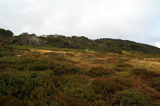
Gum trees and clouds, Mt. Gladstone


Lake Jindabyne, the view from my hotel in Jindabyne
I decided to take the most challenging route to the top of Mount Kosciuszko, which is the Lakes Track beginning at Charlotte Pass. This is a 21 kilometre bushwalk along the rooftop of Australia and provides views of five glacial lakes and of the steep, dramatic western side of the Main Range. Bushwalking guides recommend hiking in a clockwise direction, however doing so requires you to save the most challenging aspects of the walk for the end. I decided to walk the circuit in an anticlockwise direction as the last seven kilometers of the hike would all be downhill on a dirt road that has been closed to vehicles since the 1970's.
Start of the Lakes Track at Charlotte Pass - you can see the track crossing distant mountains


Snow Gums


Snow Gums
Snow Gums
Descending from Charlotte Pass towards the Snowy River


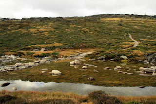
Snowy River


Crossing the Snowy River on stepping stones
Looking back toward Charlotte Pass


Crossing Club Lake Creek

Looking back toward Charlotte Pass - you can see the trail snaking up the distant mountain. 2 k's down and 19 to go with rain in the forecast


Ascending to Blue Lake with a view of Mount Lee to the west. Juicy clouds crossing the Great Dividing Range - I'll have to be passing through these clouds soon


Still on my way to Blue Lake and getting a bit concerned over the appearance of the clouds. Nothing too nasty, just don't feel like being wet and cold.


More views of Mount Lee and clouds gathering over the Great Dividing Range


Hedley Tarn


Hedley Tann and temporary shelter


Still ascending toward Blue Lake


Still ascending toward Blue Lake


Crossing an unnamed stream


Blue Lake - about 4 k's down, 17 to go


Leaving Blue Lake and heading towards Carruthers Peak


Gathering clouds over the Great Dividing Range, heading toward Carruthers Peak


Passing through the clouds, no rain!


Hiking along the Great Dividing Range


Nearing Carruthers Peak, looking toward Mount Sentinel


Ascending Carruthers Peak


View from Carruthers Peak


View from Carruthers Peak


View from Carruthers Peak


Descending Carruthers Peak, Club Lake


Between Carruthers Peak Mount Lee


Club Lake and rocky terrain


Rocky terrain. Snowy mountains are made from granite


Heading towards Mount Lee


Northcote Pass and Albina Lake


Albina Lake from Northcote Pass


Northcote Pass and Albina Lake


Albina Lake and Northcote Pass. I actually had mobile phone reception here...


Northcote Pass and Albina Lake


Northcote Pass and Albina Lake


Northcote Pass and Albina Lake


Northcote Pass


Ascending towards Muellers Pass


Getting close to Kossy


Getting closer...


Must have been quite hard work constructing this trail


Nearing the end of the Main Range Track, getting close to Kossy


Mt. Kosciuszko Track to the highest point in Australia


Still ascending toward Blue Lake


Still ascending toward Blue Lake


Crossing an unnamed stream


Blue Lake - about 4 k's down, 17 to go


Leaving Blue Lake and heading towards Carruthers Peak


Gathering clouds over the Great Dividing Range, heading toward Carruthers Peak


Passing through the clouds, no rain!


Hiking along the Great Dividing Range


Nearing Carruthers Peak, looking toward Mount Sentinel


Ascending Carruthers Peak


View from Carruthers Peak


View from Carruthers Peak


View from Carruthers Peak


Descending Carruthers Peak, Club Lake


Between Carruthers Peak Mount Lee


Club Lake and rocky terrain


Rocky terrain. Snowy mountains are made from granite


Heading towards Mount Lee


Northcote Pass and Albina Lake


Albina Lake from Northcote Pass


Northcote Pass and Albina Lake


Albina Lake and Northcote Pass. I actually had mobile phone reception here...


Northcote Pass and Albina Lake


Northcote Pass and Albina Lake


Northcote Pass and Albina Lake


Northcote Pass


Ascending towards Muellers Pass


Getting close to Kossy


Getting closer...


Must have been quite hard work constructing this trail


Nearing the end of the Main Range Track, getting close to Kossy


Mt. Kosciuszko Track to the highest point in Australia
At the top of Mt. Kosciuszko - apparently I'm not the first one to scale the peak
Lunch
View from the top of Kossy
View from the top of Kossy. There's another route to the top of Kossy - you can take the chairlift from Thredbo and then walk the last five kilometers to the peak. The Lakes Track is much more satisfying.


